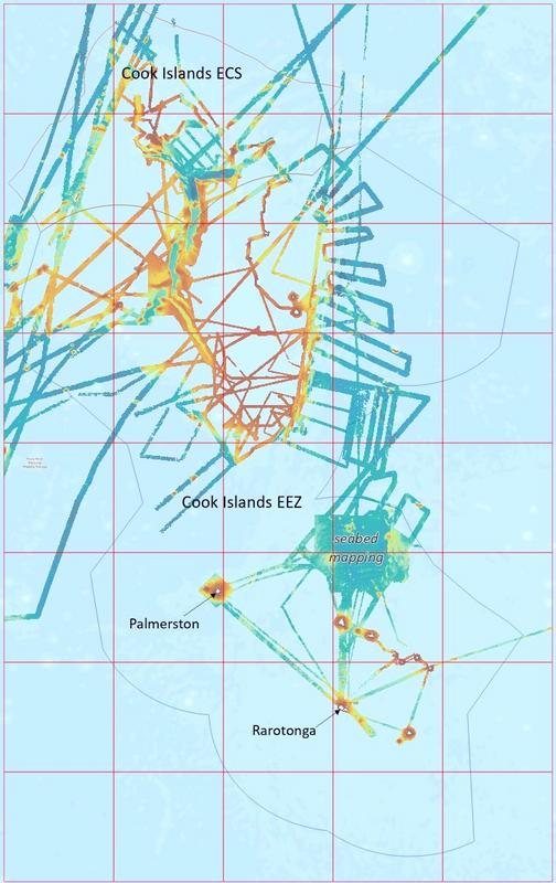
The Seabed Minerals Authority (SBMA) has released the 2025 Cook Islands National Bathymetry Grid, marking a significant step forward in the country’s marine data capability and ocean management framework.
Now available through SBMA’s Seabed Data Repository, the new national grid integrates historic and recent survey data to deliver the most comprehensive picture to date of the Cook Islands’ seafloor. Bathymetry — the measurement and mapping of the depth and shape of the ocean floor — plays a critical role in marine planning, navigation, scientific research and resource management.
SBMA said the 2025 grid represents the first release of a new national product that will be updated and published annually as additional data becomes available, strengthening long-term ocean governance and evidence-based decision-making.
In parallel with the national grid, SBMA is also developing island-level bathymetry grids and maps to support local communities and marine users. During a recent visit to Aitutaki, the SBMA team presented residents with a detailed bathymetry map of their island, aimed at improving local understanding of surrounding marine features and supporting community-based marine management. Future island grids will be similarly updated as new data is collected.
The release aligns with SBMA’s Research Priority 1, which focuses on improving the understanding of the Cook Islands’ marine environment through high-quality baseline data, seabed mapping and scientific research. The priority underscores the importance of building a robust geospatial and environmental knowledge base to inform marine spatial planning, environmental stewardship, sustainable economic development and responsible seabed mineral activities.
By consolidating fragmented datasets into a unified national grid, SBMA is advancing its commitment to transparency, scientific integrity and open data access. The bathymetry grid is expected to support government agencies, researchers, maritime operators and coastal communities in making informed decisions about ocean use and conservation.
The Cook Islands, which oversees one of the largest exclusive economic zones in the Pacific, continues to invest in ocean science and data infrastructure as part of its broader strategy to balance environmental protection with sustainable marine development.
The 2025 Cook Islands National Bathymetry Grid can be accessed via SBMA’s official website.